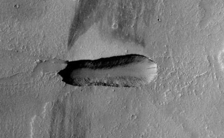
Some anomaly hunters are of the opinion that this oblong anomaly is an object on top of the surface of Mars whereas others are of the opinion that this is a ditch, I tend to agree with the later group.
The sunlit areas of the surrounding craters and the trench are located to the right whereas the shaded areas are located to the left (this is also so for the small crater inside the trench).

The trench measures 2.2 km long with an average width of 600 m. The deepest point is in the shaded area and the entrance to the trench in the sunlit area.
The edges of the trench are well defined and appear to be perpendicular to the Martian surface. The sand next to the walls at the bottom of the trench probably gathered there due to the walls eroding over time. Excavated sand seems to be spread out next to the trench to the North.
I consider this trench to be artificial in nature due to the fact that it has a geometric shape, has symmetry and the edges and walls are well defined.
The only way to see the object clearly is by using the NASA image viewer located to the left of the web page. Click the “Toggle full page” icon followed by the “Zoom in” icon. Click on “Zoom in” until the maximum image size is displayed. I tried downloading the higher resolution .TIFF image however it does not open once downloaded, perhaps the PDS files will work.
I followed the process described above, combining several screenshots into a large, complete image which you can download here (file size: 8.7 Mbytes).
I tried downloading the original PNG, GIF, JPEG, TIFF and PDF files; however the resolution of each is too low to see the object clearly.
The trench is viewable on Google Earth/Mars at the following coordinates: 13 degrees 20’35.35″N
115 degrees 35’56.27″W.
Whistleblower Corey Goode has testified that we have dug artificial trenches to hide underground bases on other planets using a technique similar to that used in Project Iceworm (machines being adapted to handle sand in this case).
Original NASA source: http://viewer.mars.asu.edu/planetview/inst/ctx/F01_036124_1930_XI_13N115W
#P=F01_036124_1930_XI_13N115W
Google Earth (Mars): Coordinates file: Artificial_Trench_Google_Earth_Coords.kmz (Google Earth to be pre-installed)
Download Google Earth (which includes the Moon and Mars): https://www.google.com/earth/desktop/ (for all operating systems)
Download Google Earth (which includes the Moon and Mars): googleearth-win-7.1.8.3036.exe (for Windows XP – local download)
Is this perhaps an artificial trench made by Secret Space Program engineers for the purpose of hiding a base there in the future, perhaps the plan was abandoned a long time ago?
Perhaps this is another abandoned open-pit mining quarry on Mars.
Subscribe to my YouTube channel and turn on notifications to be notified when new videos are uploaded.
Also visit Twitter page @RaptorZN_.
